San Antonio River Road
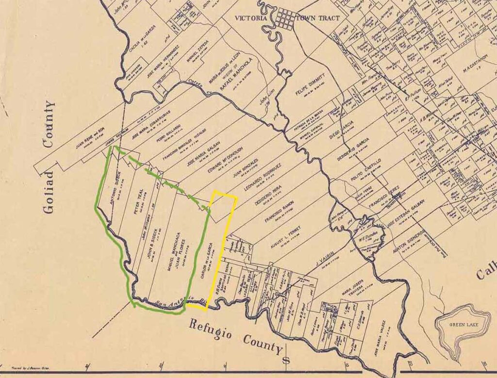
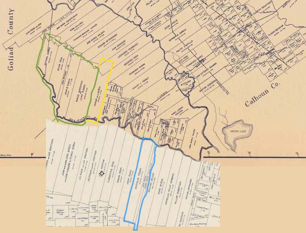
To put things in perspective, it helps to know the road and where the ranchos were. You can compare this map above with a road map today. The Coleto Creek joins the Guadalupe River between grants to Juan Gonzales and Patricia de la Garza, and the Guadalupe meets the San Antonio River at the bottom right of the map near Green Lake. Obviously, the San Antonio River marks the border between Victoria and Refugio counties (on this map view). So, the old San Antonio River Road cut roughly between the grants, midway between the two rivers — accessing all of the ranches in this area. It starts at the intersection with FM 446 and ends at Warburton Road just past the de la Garza ranch entry.
Within the Miguel Manchaca grant area was the ranch inherited by Mary Genevieve DuBois Matthews and where I grew up. What is significant about these grants outlined in green is — they were all owned and managed by Fagan women at one point in time — daughters of Nicholas. Anthony Sideck was married to Catherine. Peter Teal was married to Annie. A sliver in the middle was willed to the family by John Williams. John Fagan also bought out John Bautista Sideck grant.
Grants outlined in green were one of the Fagan ranches. The yellow outline shows the de la Garza Rancho (originally, but he bought more property next to his). And the blue is Nicholas Fagan and two sons, John and James, grants in Refugio County. Note that Carlos operated a ferry across the San Antonio River, so getting back and forth across to visit family would have been easy. Straddling the line between the Manchaca and J.B. Sideck grants was Lewis Bend, where the Seabourne Lewis plantation was located.
Setting the Stage
Riding up and down this road on your horse or in a buggy — you would have passed little houses and pens right at the edge of the road, and you would have seen winding sandy roads heading back towards each of the rivers where the bigger ranch houses might be. The land sides (as opposed to the river sides) of these grants would have been of less value, so it would be of little consequence for a rancher to give away a bit of land along the road. Along the road were a dozen or more little places that were owned by the Black cowboys and their families — emancipated slaves who had either bought or been deeded bits of land of their own.
We find Betsy Carlos and her family living and working in this community for all of their lives. The locals called it Carlos Rancho and later Anaqua. It may be that the land where Betsy lived was the site of the Seabourne Lewis Plantation — called Lewis Bend after that family dissolved. One imagines that Carlos (and Vicinte) took good care of this little family until his death in 1882. Betsy would have been about 50 years old then. Her youngest child, little Betsy, had been born the year before Carlos died.
Census Records
Generally speaking, between 1860 and 1940, Federal Census Records that enumerate the River Road are Justice Precinct 3-4, Victoria County, Texas.
Interesting Facts
This area was obviously settled before the Texas Revolution. Some of the land changed hands, but mostly grants that were sold went to neighbors who wanted to acquire more property. Many of these ranchers had been neighbors for over 20 years by the time the Civil War broke out. First and second generations answered the call to war — on different sides. And when it was all over with, many came back to the area to live and work together as stockraisers again. The 1890 Texas Union Soldiers Schedule notes these names: Vicente de la Garza (son of Don Carlos), Lorenzo D. Heaton, Edward O’Reilly, Wellington Sample, Dan Sullivan, Adam Summers, and brothers Croggan L. and Timothy R. Terrell.


